My submission:
I am a native-born Las Crucen and fifth-generation Southern New Mexican. My wife and I have enjoyed recreating on the BLM lands in Dona Ana County for years with family via four-wheel drive vehicles, hiking, camping, and recreational target shooting. I grew up with my father taking me out to the desert in his four-wheel drive trucks and learning to shoot and camp in the desert surrounding Las Cruces. We have created many fond memories over the years, and I would be devastated to see these areas closed to their current primary users. This land is very special to us, and deserves protection along with management for sustainability, but the current national push toward wilderness and wilderness-like areas is unacceptable. These designations unfairly restrict the current primary and historical uses of the land and effectively close them to most user groups. The pervading "management by closure" policy is not management. Public land should be open to the public for a diverse set of uses.
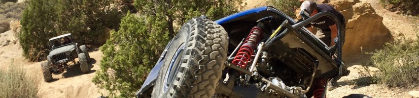
Motorized users are all-to-often marginalized and restricted from public lands. Despite the all-time high popularity of motorized recreation, motorized users have already lost many world-class opportunities in Dona Ana County, as well as across the nation as a whole. My wife and I primarily visit these lands within the Organ Mountains-Desert Peaks National Monument with modified four-wheel drive vehicles. The rock crawling opportunities in the Robledo, Dona Ana, and Sierra de Las Uvas Ranges are truly unique and nationally recognized. The annual Chile Challenge event organized by the Las Cruces Four Wheel Drive Club was a nationally recognized and covered event until it was pushed out of Dana Ana County due to the Paleozoic Trackways National monument that brought hundreds of vehicles and thousands of participants and spectators out to Dona Ana County. This also made Las Cruces one of the main rock crawling destinations in the 1990s and early 2000s, bringing visitors from all across the nation throughout the year. Some of the earliest competitive rock crawling competitions and series began in the Las Cruces area as well. These motorized users, sponsors, and vendors brought large amounts of money to the community through lodging, fuel, camping, restaurants, and automotive parts and repair.
Other communities such as Farmington New Mexico, Hurricane Utah, and Moab Utah have embraced motorized users and reaped the economic benefits of welcoming these user groups to their communities. Las Cruces has lost out on this due to misguided land managers and the extremely vocal Southwest Environmental Center which has had disproportionate influence on land management policies throughout the county. These policies and groups do not represent the interests of the community at large.
The amount of land set aside for non-motorized use is disproportionate to the population of non-motorized users who cannot co-exist with motorized users. Motorized users are consistently marginalized to small areas of land with low recreational value such as the Aden Hills OHV Area. The Robledo, Dona Ana, and Sierra De Las Uvas Ranges are far more popular with motorized users despite not specifically catering to motorized users because these lands are far higher in motorized recreational value and represent unique opportunities for users such as technical rock crawling.
Responsible motorized users such as those affiliated with the Las Cruces Four Wheel Drive Club work to promote and educate users on responsible and sustainable motorized land use. I have personally participated in club-sponsored clean up efforts in the Robledo and Dona Ana mountains. I have not however, seen similar efforts put on by the so-called “green” and “environmental” groups. Any issues identified with motorized users could be resolved with education, engagement, and active management on the part of land management agencies. Many problems stem from lack of information and signage available to users. The largest threat to the lands in the Organ Mountains-Desert Peaks National Monument does not come from recreational users themselves, but from members of the community that participate in illegal dumping that has been exacerbated by landfill fees in the city and county.
I am skeptical of the Organ Mountains Desert Peaks National Monument since we have repeatedly lost recreation opportunities, particularly of the motorized variety, with every monument and wilderness land designation over the years. The following quote is from Lance Harkey, one of the early pioneers of the Las Cruces Four Wheel Drive Club (formerly the Las Cruces Jeep Club), reflecting on land access for motorized use from the formative era of the club:
“There were trails all over back then. I was at the first meeting when they promised that if we supported making the Robledos a Wilderness Study Area, we would always have access to the roads and that they could not be closed. We do have old recordings of this meeting. Since then there have been trail after trail closed. Snake Road, The Mine Loop, Bishop's Cap, Dripping Springs road in the Organs, the road along the entire west side of the Organs. Roads that went from Dripping Springs to Soledad Canyon, the road on the west side of the Robledos that went to Falkner Canyon, the road that went from Dona Ana Mountains to Radium Springs, The Wolf Run and The Guardian.
Many of the roads in this area were built in the 50's and 60's. I remember hearing Doug Bogart tell me the old club spent two days opening the road into the Robledos that was later called the Wolf Run and the exit road to Skyline. They said that the Jeeps were loaded with tires because they keep destroying them as they climbed the desert mountain. Later the BLM used the example of this road as a new opening to close the whole area two decades after it was opened. They never realized that that was the first road to Skyline.
This club and the old Las Cruces Jeep Club helped build this sport. But as much fun as driving was, the real value was the friends and the memories that this club has passed on to its members. The trust and friendship that developed working together to get the four wheel drives into and out of the back country taught the members not only how to drive but how to live.”
Since Lance Harkey wrote this, several more nationally recognized trails, such as Cayenne Crawler, Patzcuaro’s Revenge, and Tabasco Twister, have been closed as well as a result of the establishment of the Paleozoic Trackways National Monument. These closures are leaving motorized users with few recreation opportunities and forcing them to travel hundreds of miles for opportunities similar to the ones that have now been lost.
As someone who has recreated on the land now under the Organ Mountains-Desert Peaks National Monument their entire life in various forms, I do not support the closure or restriction of any motorized recreation opportunities within the monument boundaries. Closure is not management, and the area represents truly unique, high-value motorized recreation opportunities that would be a travesty if lost. Motorized users have already lost too much and Non-motorized users have a disproportionate amount of land designated for their use. Motorized access allows people to see and enjoy more of the land than non-motorized modes of travel do and empowers the elderly and disabled to enjoy recreation opportunities that they otherwise would not be able to experience. Special-interest and environmental groups do not represent the desires of the community at large and should not be allowed to have undue influence on land management plans and policies.