You are using an out of date browser. It may not display this or other websites correctly.
You should upgrade or use an alternative browser.
You should upgrade or use an alternative browser.
Norcal Cow mountain?
- Thread starter Clb
- Start date
- Joined
- May 19, 2020
- Member Number
- 315
- Messages
- 260
No, the next time I would maybe be able to go up would be labor day weekend nowDid you go up today?
I'm just hangin out.
Clb
another toyota from P.R.K
Scotts creek aint to deep, the 2 ponds on the entrance road from 101 where the old redwood run was at are deep.
Dunno if access would be good for swimming tho this being the prk and all.
Just got back from slickrock, so been off coms lately, Are you guys going in to cow soon?
Dunno if access would be good for swimming tho this being the prk and all.
Just got back from slickrock, so been off coms lately, Are you guys going in to cow soon?
Last edited:
Hooligan
Xtreme wheeler of the web
Figure I’d post a weekend Trip report. Was my first time there. My usual research method YouTube, doesn’t have a lot of recent 4x4 content.
Place was dusty already, couldn’t tell that rains had just ended. There were a few places with standing water. I’d like to go back after a recent rain.
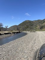
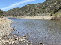
Went in through Lakeport/Scott’s Valley Creek. Nice creek area, water was 1-2 feet deep and you could drive across in a few areas. Looked nice enough to sit in a lawn chair during the summer heat.
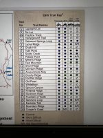
Trails are rated green (easy), blue and back diamond (hard). Many also say not recommend for long wheelbase.
Not familiar with there ratings, we started with a green trail #15. Well, it was easy, only used 4x a few times. Spent about 3 hours doing trail maintenance , this was the worst spot.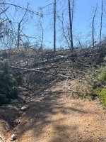 Took about 45 minutes as there were numerous trees and more around the corner. The trail rating system should also include a paint damage rating. Holy shit. The manzanita and whatever the hell that bush with thorns is have invaded the trail. This trail was really only wide enough for a SxS sue to excessive brush. Trail was so narrow with brush no way a motorcycle could have even fit through to pass by me. Good thing there was no traffic, if another group was coming through one of us would have to reverse several miles. Most of the trails loop back to the main road, surprised they aren’t directionally controlled. Lots of blind corners, I was hesitant to drive to fast since I would not be able to stop if a MC or SxS was jamming along.
We cleared # 15, so it is now open end to end.
Red Mountain campground was full. We found a better spot, just minutes away down a dead end road. Had an awesome view of Clearlake, Lake Mendocino, and Snow Mountain.

Place was dusty already, couldn’t tell that rains had just ended. There were a few places with standing water. I’d like to go back after a recent rain.
Went in through Lakeport/Scott’s Valley Creek. Nice creek area, water was 1-2 feet deep and you could drive across in a few areas. Looked nice enough to sit in a lawn chair during the summer heat.


Trails are rated green (easy), blue and back diamond (hard). Many also say not recommend for long wheelbase.

Not familiar with there ratings, we started with a green trail #15. Well, it was easy, only used 4x a few times. Spent about 3 hours doing trail maintenance , this was the worst spot.
 Took about 45 minutes as there were numerous trees and more around the corner. The trail rating system should also include a paint damage rating. Holy shit. The manzanita and whatever the hell that bush with thorns is have invaded the trail. This trail was really only wide enough for a SxS sue to excessive brush. Trail was so narrow with brush no way a motorcycle could have even fit through to pass by me. Good thing there was no traffic, if another group was coming through one of us would have to reverse several miles. Most of the trails loop back to the main road, surprised they aren’t directionally controlled. Lots of blind corners, I was hesitant to drive to fast since I would not be able to stop if a MC or SxS was jamming along.
We cleared # 15, so it is now open end to end.
Red Mountain campground was full. We found a better spot, just minutes away down a dead end road. Had an awesome view of Clearlake, Lake Mendocino, and Snow Mountain.
Hooligan
Xtreme wheeler of the web
Woke up to some fog.


Clearlake covered by the fog

Clearlake covered by the fog
Hooligan
Xtreme wheeler of the web
Went over to the playground and did some hill climbs. Did not try the cement waterfall. Drove up and around Red Mountain, then took the main road over to Trail #20. It too was overgrown, but had a few sections more open. It was not anymore difficult than #15.
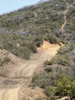
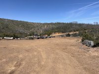
Buckhorn campground is nice, off the path, has a pit toilet and four sites with tables. Has parking for maybe 8 trucks or so.
Would I go back, with someone that knew which trails to take. Or when it rains.
Does CalOHV have a masticator, with miles of trails that need brush maintenance doing so by hand would take forever.

Buckhorn campground is nice, off the path, has a pit toilet and four sites with tables. Has parking for maybe 8 trucks or so.

Would I go back, with someone that knew which trails to take. Or when it rains.
Does CalOHV have a masticator, with miles of trails that need brush maintenance doing so by hand would take forever.
Clb
another toyota from P.R.K
They close it down after the first 2" of rainfall. Anything in like 48 hrs more than a half inch of precip and gates clised.
This info used to be on the anouncement recording.
Yes before the fire it was a pinstripe mecca.
The following year was awesome.
Then the greaseweed and manzanita came back.
Looks like great weather tho.
Last time I saw any trail maint. Done it was not the state.
Eta
The local guys and weroc or someone else, would just go do it (maint).
The state did alot after the burn I hear..
Never seen em trim brush tho.
Last edited: